Nature is the important factor of this Earth. It gives us fresh air and other needed things. It is also home to thousands of species.
I was travelling to town, and while in the journey I saw that in many buildings they have grown many small plants in their balconies. I thought to myself, what a fate, we destroyed all that forest lands and built buildings and now again we are growing plants in that building.


Today in the name of urbanisation all forest lands have been destroyed. Today we are facing so much heat, scarcity of rain, water because of this deforestation. Today all might have understood the value of forests, and trees. Though most of the forest lands have been destroyed, there are few lands which have spread over thousands and have remained undestroyed.
One such forest is ‘The Sundarbans’. The Sundarbans mangrove forest, one of the largest such forests in the world (140,000 ha), lies on the delta of the Ganges, Brahmaputra and Meghna rivers on the Bay of Bengal. It is adjacent to the border of India’s Sundarbans World Heritage site inscribed in 1987.
The site is intersected by a complex network of tidal waterways, mudflats and small islands of salt-tolerant mangrove forests, and presents an excellent example of ongoing ecological processes. The area is known for its wide range of fauna, including 260 bird species, the Bengal Tiger and other threatened species such as the Estuarine Crocodile and the Indian Python.
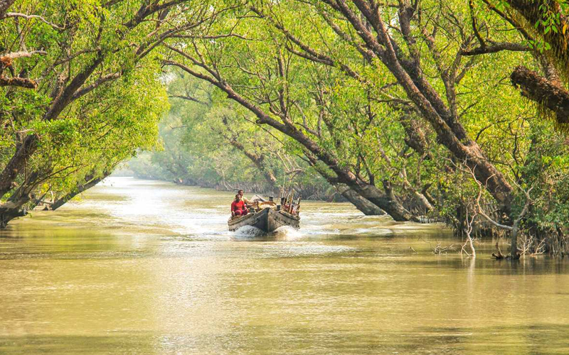
The Sundarbans Reserve Forest (SRF), located in the South-West of Bangladesh between the river Baleswar in the East and the Harinbanga in the West, adjoining to the Bay of Bengal, is the largest contiguous mangrove forest in the world.
The immense tidal mangrove forests of Bangladesh’s Sundarbans Forest Reserve, is in reality a mosaic of islands of different shapes and sizes, perennially washed by brackish water shrilling in and around the endless and mind-boggling labyrinths of water channels.
The Sundarbans mangrove forest covers an area of about 10,000 km2, of which forests in Bangladesh’s Khulna Division extend over 6,517 km2 and in West Bengal, they extend over 3,483 km2 across the South 24 Parganas and North 24 Parganas Districts. The most abundant tree species are sundri and gewa.
The history of human settlement in the Sundarbans area can be traced back to Mauryan era. During the Mughal period, forest tracts were leased out by the local rulers for establishing settlements. In 1757, The British East India Company obtained proprietary rights over Sundarbans from the Mughal Emperor Alamgir II and completed mapping the area in 1764. However, systematic forest management started a century later.
The Sundarbans – is a complex ecosystem comprising one of the three largest single tracts of mangrove forests of the world. The larger part is situated in Bangladesh, a smaller portion of it lies in India. The Indian part of the forest is estimated to be about 40 percent, while the Bangladeshi part is 60 percent. To the South the forest meets the Bay of Bengal; to the East it is bordered by the Baleswar River and to the North there is a sharp interface with intensively cultivated land.
The Sundarbans along the Bay of Bengal has evolved over the millennia through natural deposition of upstream sediments accompanied by intertidal segregation. The physiography is dominated by deltaic formations that include innumerable drainage lines associated with surface and subaqueous levees, splays and tidal flats
The physical development processes along the coast are influenced by a multitude of factors, comprising wave motions, micro and macro-tidal cycles and long shore currents typical to the coastal tract. The shore currents vary greatly along with the monsoon. These are also affected by cyclonic action.
In many of the Bangladesh’s mangrove wetlands, freshwater reaching the mangroves was considerably reduced from the 1970s because of diversion of freshwater in the upstream area by neighboring India through the use of the Farakka Barrage bordering Rajshahi, Bangladesh. Also, the Bengal Basin is slowly tilting towards the east because of neo-tectonic movement, forcing greater freshwater input to the Bangladesh Sundarbans. As a result, the salinity of the Bangladesh Sundarbans is much lower than that of the Indian side
The forests provide habitat to 453 fauna wildlife, including 290 bird, 120 fish, 42 mammal, 35 reptile and eight amphibian species. Despite a total ban on all killing or capture of wildlife other than fish and some invertebrates, there is a consistent pattern of depleted biodiversity or loss of species , and the ecological quality of the forest is declining.
The ecosystem is now one of the World’s Natural Wonders, and was declared a UNESCO World Heritage Site.